The Netherlands is an exceedingly flat country. Not the world’s flattest (that distinction belongs to the Maldives), but certainly in the top 10, with a modest high point of 1,056 feet close to the borders with Belgium and Germany. But this is only the European part of the country that used to be called Holland. In fact, the highest point in The Kingdom of the Netherlands — the official name for the federation that consists of the Western European country (98%) and overseas island territories (2%) — is to be found somewhere between Anguilla and St Kitts & Nevis, in the Caribbean’s Leeward Island archipelago.
The quaintly named Mount Scenery — rising to a much more impressive 2,877 feet — comprises pretty much all of the island of Saba, one of the Caribbean’s three Dutch “special municipalities” (Sint Eustatius and Bonaire are the others).
From a distance, it seems that the volcano rises straight out of the seabed, with dramatically steep sides and little in the way of flat terrain. And this extreme verticality has been both the curse and salvation of tiny Saba: its extraordinary topography has always created obstacles and exhausting work for its inhabitants, but it has also preserved the island’s cultural uniqueness and stemmed the relentless march of mass tourism.
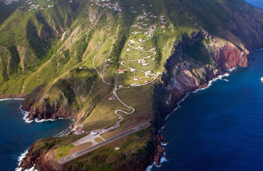
Saba can claim a couple of mini-superlatives: it is the smallest permanently populated territory in the Americas (five square miles with 1,911 residents in 2022). It also has the world’s shortest commercial runway at 1,312 feet — perhaps explaining why those tourists who come do so in limited numbers, on small propeller planes. Landing in Saba, where the runway ends abruptly with sheer cliffs and a drop into the sea, is not for the faint-hearted, as I can testify, but the airport’s safety record is exemplary.
Before the airport, however, came the saga of “The Road” — so named because Saba essentially has a single road. It was an audacious undertaking given the island’s isolation and steepness, and it was achieved despite considerable indifference on the part of the then colonial authorities. Its construction was the work of islanders, and the guiding light is generally acknowledged to be a Saban-born engineer, who died 40 years ago, in 1983. His legacy is the 8.7-mile “road that could not be built” — a vital part of everyday life in Saba.
Since its colonisation by the Dutch, those who lived on the island had to contend with steep paths and vertiginous tracks. Unsuitable for plantation agriculture, the island had few slaves and was largely populated by Dutch-descended and other European settlers who specialised in fishing, lace-making, and smuggling.
The absence of a functioning harbour meant that small schooners delivered and collected goods, and these had to be transported by humans or donkeys from the rocky inlet at Fort Bay to the main settlements of Windwardside and The Bottom. Most cargo that came ashore was carried up a lung-busting set of 800 steps carved into rocks — “The Ladder” — and into The Bottom, a village whose names derives from the Dutch Botte, the volcanic bowl in which it sits.
By the mid-20th century, it had become painfully apparent that Saba’s infrastructure was lagging behind that of other Caribbean territories. Contacts with the oil-rich Dutch colony of Curaçao underlined the problem, and Sabans who ventured abroad were not oblivious to the advantages of motorised transport. But the Dutch authorities did not view their miniature colony as a priority, and little progress was made.
After two Dutch engineers visited and concluded that a road was unfeasible, a providential individual by the name of Josephus Lambert Hassell (or “Lambee”) decided, quite literally, to take matters into his own hands. Returning home after a stint in Aruba, he undertook a correspondence course in civil engineering and learned the basics of road building, including the use of cement.
In 1943, he was ready to begin his ambitious project. And with enthusiastic volunteers and some workers paid a basic daily rate with funds from Curaçao, the road began to take shape. Veteran island historian Will Johnson points out that some preliminary work from Fort Bay to The Bottom had already been done, but it was Lambee and his team of local helpers who carried out the bulk of the back-breaking labour.
One woman interviewed by Dutch academic Nikki Mulkder recalls how the road construction was done with no mechanical assistance:
And so it was. And it was just by hand. They had no big machinery, no trucks, not anything like that. Everything, the rocks was [sic] on their heads, the cement. Everything was by hand.
Not surprisingly, it took 15 years for the main part of the road to be painstakingly fashioned through Saba’s steep and rugged landscape, with pickaxes, shovels and wheelbarrows. Eventually it reached the suitably named village of Hell’s Gate (or Zion Hill), which had provided the most determined volunteer workforce in a bid to be connected to the rest of the island.
In the meantime, according to Will Johnson in The Saba Islander, one Oliver Zagers from Hell’s Gate brought the first vehicle — a Jeep — ashore, lashed to two wooden cargo boats in 1947. It was for the use of the Dutch Administrator, and in 1955 was used to drive Queen Juliana around the island during her brief royal tour. In 1952, there were nine cars on the island, and in 1964, a total of 46 vehicles.
By then, the infamous Juancho E Yrausquin airport had finally opened on a small piece of level land on the other side of the island from Fort Bay. The first flight from Sint Maarten landed safely on 24 July, 1963 — 60 years ago. A switchback road, just over half a mile long with dizzying bends, leads up from the little airport to Hell’s Gate, and taxis ferry visitors around the island (car hire is virtually non-existent; those alarming bends and the road’s narrowness deter most tourists).
Lambee Hassell’s road is a source of great pride in Saba, a sort of “founding myth” that proves that local determination and hard work could prove the Dutch experts wrong. Plenty of YouTube videos demonstrate its spectacular and at times dangerous features, but it has stood the test of time and transformed the fortunes of Hassell’s island — the “unspoiled queen of the Caribbean”.
Saba’s sustainable tourism today — based on diving, hiking and nature-friendly activities — does not, in any case, depend on a busy road network. And in this respect, the self-taught civil engineer’s project turned out to be the perfect solution.