Carriacou and Petite Martinique feel like they exist in a world almost entirely on their own terms, and where little changes or upsets the harmony of a simple and uncomplicated way of life.
I go there whenever I can, often in June — at the end of peak holiday season — to walk forest and coastal paths, or to immerse myself in a cultural heritage that’s as ancient as the island’s first Amerindian settlers, and with roots as diverse as Scottish boatbuilders and enslaved Africans.
My last visit took in its beguiling Carnival celebrations and its unique tradition of Shakespeare Mas. Here I am again, ready to roam.
In the dry forest margins, something stirs. Goats. Or are they sheep? I’m never sure. They step out onto the dirt track in numbers, bleating loudly at this solo walker who has disturbed their dawn forage.
My hair is still wet from the sea, black volcanic sand still trapped in my shoes. I went for a swim at first light in the placid waters of Anse La Roche bay — just a 20-minute diversion from the main track.
I’m walking around the top end this morning, from Bogles on the west coast to Windward on the east. It’s a two-hour journey that skirts the margins of Carriacou’s High North National Park, whose main attraction is the aptly named High North Nature Trail, a two-mile forest hike to the island’s highest point (955 feet), where there are gorgeous views of the southern Grenadines.
Continuing along the north coast, I reach Petit Carenage. Here, a short trudge through the swampy L’Apelle Mangrove Forest, a protected area for migratory waterbirds, brings me to one of my favourite Caribbean beaches.
It’s a long slip of deep white sand, deserted and beautiful, with a rusting shipwreck sitting defiantly upright against the shoreline, and a shallow coral formation extending to distant breakers all around the northeastern tip of Carriacou, this alluring island of reefs.
Across the water are the islands of Union, Mayreau, Petit St Vincent, and Petite Martinique.
I reach the sleepy boatbuilding community of Windward just in time for a ride I had planned — a small private launch that I would share with the island’s doctor who is heading over to Petite Martinique to conduct his weekly surgery.
It’s a 20-minute, easy crossing, and we chat about the boatbuilding tradition of the two islands and his view that it’s in decline, with young men opting instead to make a living from commercial tuna fishing.
I recalled being in Windward for two boat launching ceremonies in the past, when traditional Carriacou sloops were celebrated with lashings of rum, oil-down cooked over open fires, and the singing of shanties. And I hoped all was not lost.
In Sanchez, where we disembark, I’m relieved to see two wooden fishing boats under construction on the shoreline, and further along the coastal road, I see a half-built wooden speedboat sitting in a barren garden alongside an old pickup truck on blocks with its rear wheels missing. Two young men emerge from a house and wave hello with spanner and hammer before setting about their repair and construction work.
I walk for an hour, covering the full length of the single lane road that links the residential community of Madame Pierre to the wilds of En Haut.
Beyond that, there’s a dirt track that continues around the far side of the island and up to the top of Piton (740 feet), Petite Martinique’s single conical peak.
I sit in the short, dry grass at the remote Kendace Point with just sheep, or maybe goats, for company, and enjoy the views through Sahara dust haze to Carriacou.
After a couple of hours, the doctor has finished and we ride the launch back to Windward where I catch a bus to Hillsborough, Carriacou’s main town.
Sauntering along Main Street, I look to see if much has changed, but everything seems to be the same as it was the last time I was here, when I’d been plastered in paint powder and engine oil by jab-jabs at J’ouvert. I grab a mango juice to go from Kayak Café on Main Street and walk south out of town along an empty shoreline.
About a mile out of town, the paved road ends at Lauriston Airport. I walk along the beach to a grounded shipwreck and look for a track through the mangroves. It’s still there and well-beaten.
This 15-minute trail cuts conveniently across Lauriston Point, joining Hillsborough Bay with L’Esterre Bay and Paradise Beach — without a doubt Grenada’s loveliest stretch of sand. I emerge from the mangroves and splash through the shallows to the Hardwood Bar where I order lambie and beer, and wait for sunset.
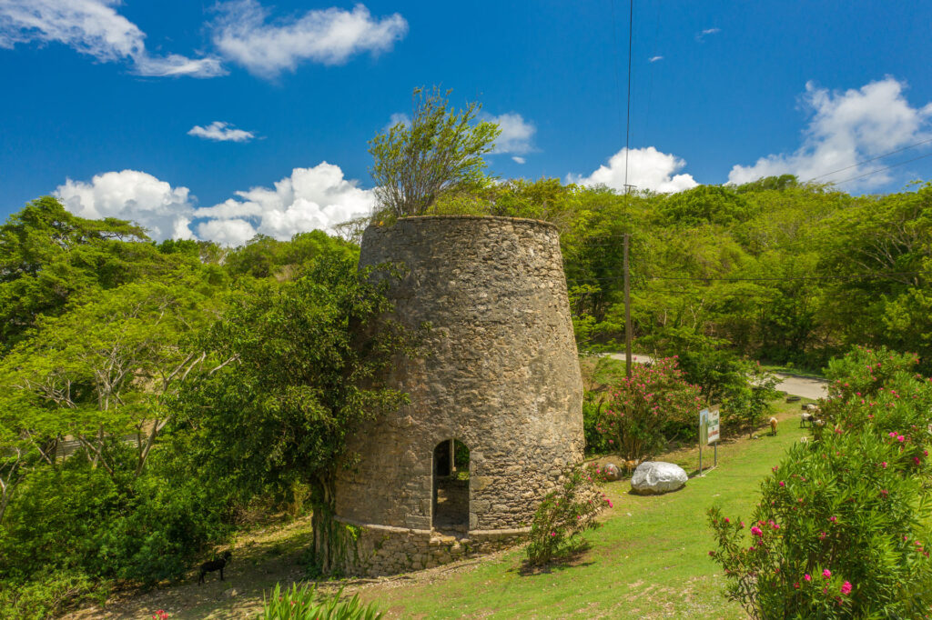
The next morning, along the island’s high central ridge, I pause at the Belair windmill ruin before setting off on a hillside track through the Limlair estate towards the Atlantic coast.
The mill is one of several that were built from local stone and lime mortar on exposed windblown areas of Carriacou. They once housed machinery to process sugarcane that was grown and harvested by enslaved estate workers.
The contemporary Limlair estate is part farmed, part fallow. Sheep and goats roam freely. I’d heard that farmers who can’t sustain increasing numbers of goats simply set them loose to fend for themselves.
I meet plenty of these ovine vagabonds on my hour-long walk down to the rugged coast, where the ocean consumes sargassum-covered gravestones at the hauntingly desolate Tibeau cemetery.
Nearby is the Indigo “Ningo” Well, a large stone cistern that was constructed by the enslaved and used to produce dye from harvests of indigo plants that were grown on the Limlair estate. The mordant used in the dyeing process — probably calcium hydroxide, made from lime — is said to have caused the enslaved workers significant health problems.
The mile-long coastal road from Bay à L’Eau to Mount Pleasant is unpaved. Before each general election, there’s a flurry of activity suggesting its long-awaited repair, then little happens. But the goats and the sheep don’t seem to mind.
Reaching Grand Bay, where the road turns inland to Top Hill, I continue along a rough coastal path towards a region called Sabazan. Along the ever-eroding sand banks, Amerindian pottery artefacts spill from the ground in their hundreds.
I examine several fragments of Cayo ceramics from what was probably a pre-Columbian midden ground that now mixes with the jettisoned flotsam of the 21st century. Surprisingly, this site appears to have no official recognition or protection, and I wonder how much longer it will survive.
The Sabazan coastline is remote and beautiful with sweeping views across Breteche Bay to the uninhabited Saline Island and White Island.
Passing the ruins of the former L Rose & Co lime factory at Dumfries, I walk a further mile along the rugged, boulder-strewn landscape of Black Bay to the tiny hamlet of Belmont.
Clambering up a grassy headland to the bemused stares of grazing sheep, or goats, I pick up the main road to the village of Harvey Vale on Tyrell Bay.
The expansive natural anchorage is crowded with boats at anchor, and the Osprey ferry is preparing to leave for St George’s. Yachties, rediscovering their land legs, browse shoreline shacks for fresh fruits, while others load dinghies with fuel and provisions.
Beneath the shade of a sprawling almond tree, I sip a cold beer from the Lambie Queen and plan my next escape to the island.